
We planned to explore the northern part of Santorini starting with Imerovigli a very nearby town. We would be walking from our hotel to Imerovigli. Another town that I had heard a lot these two days in Santorini was Oia town, many told us that Oia was a must see place in Santorini. So Oia would be our second town of the day.
 |
| Our destination: Northern Santorini |
Imerovigli
Though we had not visited Imerovigli we had seen the town from Firostefani, from the roof top of our hotel. We had half a day to explore Imerovigli. After breakfast we set out from the footpath just outside the doorstep of our hotel walking northward. The footpath brought us past many beautiful houses, hotels, cafes, shops and churches that lined both sides of the footpath.
 |
| Firostefani |
Along the footpath there was just a short section where the houses thinned out that was the boundary between the two towns. In Imerovigli the footpath path branched out to steps leading up and down to doorsteps of more hotels and churches further up and down of the caldera cliff.
 |
| Firostefani |
In the morning, the sky was very blue with not a single cloud to break the continuous stretch of brilliant blue above our head. There were not many people out walking, most tourists were still lazing by the sun chairs of their hotels, eating breakfast as they enjoyed the view of the caldera. I could understand why some people were paying thousand of dollars just to booked a room/hotel facing the caldera. The view of the sky and the Aegean sea was stunning all day round.
 |
| A Imerovigli Hotel facing the Caldera |
Skaros Rock
At Imerovigli we saw a huge odd shape rock sticking out of the mainland. From far the rock looked like a high triangular fortress but walking closer it was a huge triangular column of rock. There was a walking path that linked the mainland to the rock. I was eager to explore the rock but my hubby wanted to stay back to take more photo. We went our separate ways and I began an unforgettable exploration.
The rock was further than my expectation, I kept walking downhill for a long time until I reached the "neck" piece of land that joined the mainland to the rock. Along the way I only met two other persons. At interval I would receive a phone message from my hubby to turn around and wave at him.
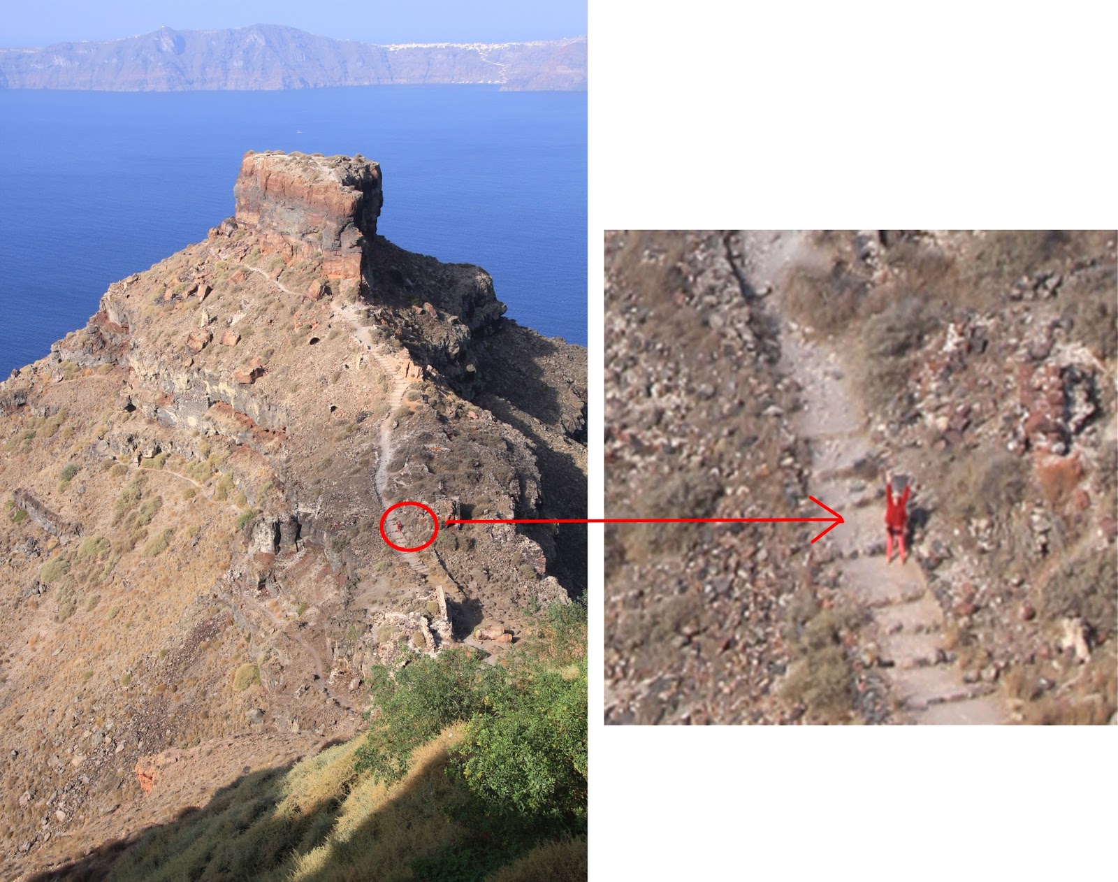 |
| Trekking toward Skaros Rock |
After crossing the "neck" the path when upslope. The steps ran out and I followed the uneven rock path towards Skaros rock. Skaros rock was many times larger when I reached it. It loomed up like a huge fortress city towering up in the sky. I trekked on, up the gentle slope until I was at the base of the monstrous triangular column.
My intention was to make a loop at the base of the humongous column and after completing the loop to return to the mainland and meet up with my hubby. I decided to walk a clockwise loop since the path on the left was more obvious than the one on the right.
 |
| Taking a clockwise route |
As I walked on, the path soon disappeared but I continued walked on. There were rocks everywhere some of which were so huge that I had to walk around them. Since there was no definite path I took the route of least resistance. Sometimes I went upslope and sometimes downslope. I just put my foot down where I felt it was safe to tread. The terrain was very rough and rocky but not slippery at all.
Interestingly when I was at the back of the column, I saw a monastery at the lower end of Skaros rock nearer to the water level. I could only see the back of the monastery from where I stood. It had a blue dome and two-tiers bell tower and its front was facing the sea. The monastery looked so clean and well maintain definitely not a ruin.
 |
| A monastery on the base of Skaros Rock |
I thought of going down to explore the monastery, but from where I stood I could not see any path leading to the monastery. It was too dangerous to attempt approaching the monastery by climbing down the slope so I stayed put. This was the second time I saw a well maintained monastery in the middle of nowhere. I couldn't help wondering about the purpose of such a monastery. Maybe it was not intended as a place where the worshippers come to pray but a santuary for the monks.
Sitting on the slope at the back of the Skaros rock I could see the next island clearly. That island in front of me must be Thirasia. I could see the white houses on the top of its caldera cliff and the zig-zag road that linked the port at the bottom of the cliff to the town on top.
 |
| Caldera of Thirasia |
After 30 minutes of rest I moved on. Since I remembered walking downslope earlier on to take a closer look at the monastery, I naturally continued my clockwise loop trek in an upslope direction. I trekked on upslope for quite sometimes and then I saw three tourists climbing down from a 3 metres high ground in front of me. I asked the lady if that was the way back she smiled and nodded her head. Her male companions told me not to worry it was not too difficult to go up and the climb was worth it. So for the first time in my life I scrambled up 3 metres gripping on rock protrusions and stepping on rock crevices. The rocks were very rough and they provided very stable traction. The last metre was the most strenuous as I practically hugged the top ledge and crawled up. I thought good I was on way home finally.
Oh My God!!!! I did not complete the loop, I was on the very top of the Skaros Rock!
Oh My God!!!! I did not complete the loop, I was on the very top of the Skaros Rock!
 |
| Alone on top of Skaros Rock |
I walked to the front of the triangular top to check for a path down but there was no path just a steep drop. My handphone rang, a message came in, my husband had spotted me from his telephoto lens and told me to lift up my hands to show a victory sign for my accomplishment. I did it half heartedly as I was in a panic searching for a way to go down.
 |
| Help!!! Where to get down? |
I wanted to backtrack, but in my panic I forgot the spot where I had climbed up, I searched around the perimeter of the ledge but everywhere I looked were steep vertical drops. I was wondering if I should get my hubby to call for help. I did not because I did not want to send him into a panic too. I thought I would just wait for some tourists to come up and then I would know where to go down.
After 10 minutes I gave up waiting and slowly explored the perimeter of the ledge again focusing generally along the section that I would have climbed up. Back in my mind I had this thought running though "Singapore woman fell to death on Skaros Rock". Making my best bet I crawled down backward on my stomach at the spot that I hoped was the right spot.
Jackpot I was correct. Though the 3 metres climb down was high and difficult it was not slippery, I made it down safely. Getting "lost at the top" had shaken me, and I did not want to continue my clockwise loop anymore, so I backtrack and walked anti clockwise back to the start of the loop and met up with my husband on the mainland.
Thinking back if I had not got lost I would not have been up to the top of the Skaros Rock. All my panicky emotion were not totally wasted as my daring adventure was forever captured in photo by my hubby!
History of Skaros Rock
Skaros was a fortified settlement that was inhabited in medieval times. It was one of the five fortified settlements and the most important one and was constructed to offer protection from pirates. A castle was built on Skaro in the Byzantine years and a whole settlement was built around and below the castle. On top of the rock hung a large bell to warn inhabitants of imminent pirate raids.
Lunch at Oia
We drove northward along the west coast of Santorini to Oia town which was 11 km from our hotel. This was our second trip to Oia, the first trip was done two days ago in the late evening. There was a lot more to see in the day time.
 |
| Route to Oia |
We drove for about 30 minutes to reach the center of Oia town. From the road level the town did not look very spectacular. There were the usual shops, hotels and restaurants. As usual the best part of town would be at the cliff side where all the white houses stood and not along the main road.
It was time for lunch and we wanted to pick a restaurant that would serve authentic Greek dishes that locals would typically eat. We stopped at a restaurant, Alkiona (or Alkyona) by the main road, it looked like a local restaurant, its interior deco was simple and quaint. We requested specifically for a Greek dish and were recommended the mouzaka a tradition Greek food. Yummy, absolutely delicious it was a baked potatoes, cheese, minced beef, lamb and pork concoction.
 |
| Alkiona Restaurant (co-ordinates: 36.462677, 25.380705) |
Ammoudi Beach
The waiter at the Alkiona restaurant recommended that we should visit Ammoudi Bay which was just nearby, he told us that Ammoudi Bay was the jewel of Oia. We drove toward Oia town centre and took the left turn and followed the road sign that point to the bay. The road went downhill all the way down to the coast. The last stretch of the road was pretty straight and slope down gradually with a high cliff on the left side and a drop into the sea on the right side.
 |
| route to Ammoudi Beach |
From far it looked like the road would ended at the seafront. We parked our car at the road side and walked down the road till the end. Surprisingly at the end of the road there were steps that led down to a path which was out of sight from the main road. The sandy path curved further left and we reached Ammoudi bay.
Wow! Ammoudi Bay was very beautiful.
Wow! Ammoudi Bay was very beautiful.
 |
| Ammoudi Bay |
This bay was at the base of a beautiful red cliff. It was a small seaside town with many outdoor cafes and restaurants selling mainly seafood. Looking up we could see the town of Oia on top of the cliff. There was a long zigzag stair that linked Oia town all to way down to the Ammoudi bay.
 |
| Fresh Seafood at Ammoudi Bay |
It was a wonderful and relaxing experience to sit under the shade of the sun umbrella, enjoying a cup of coffee, feeling the cool strong breeze, staring at the rough sea and seeing the boats bobbing up and down in the water.
Capturing the sunset at Imerovigli Town
On the first evening at Santorini we photographed the sunset over the Aegean sea from Fira Town, on the second evening from Firostefanie town, this evening which was the third evening we walked to Imerovigli Town to photo shoot the sunset. The best time to photograph the town was just when the sun was about to set, just when it golden rays cast on to the white wall of the white houses turning giving them a golden glow.
 |
| Sunset over Imerovigli Town |
The scenery was very beautiful and we stood there overlooking the caldera till the sun went down, until the lighted came on and until the sky turned pitch black.
 |
| Imerovigli Town at Night |
Dinner at Remvi
Remvi restaurant was just a couple of metres from our hotel and we had walked past it every time we walked to and fro a nearby car park to our car. On this last evening in Santorini we walked into Remvi restaurant to had a late dinner, the place was packed with people. Though it had an open terrace the weather was too cold and the wind too strong to eat outdoor. Our table was just near a "plastic sheet" sliding door and every time it opened I felt a gush of cold wind blew in.
We ordered a mixed grill plate of meat for both of us which came in huge portion. The food was tasty but a bit too dry for my taste.
 |
| Dinner at Remvi Restaurant |